22 April, 2014

Albert Icefields Trip: A Week In The Deep Freeze

Earlier this year my friends, Justin, Gavin and I had planned a week of ski touring up on the Albert Icefields, below Selkirk Lodge for February.  We had set the dates aside in September but little did we know the dates we had chosen was going to be one of the coldest weeks of the winter, with temperatures dipping below -30 degrees C each night.  But stubborn as we were, the skiing and terrain was going to be fun, so we committed to cold nights and cold days.

(Video:  Justin Ormiston)
We were flown in, with the gracious permission of Grania who runs the lodge, with Selkirk Tangiers helicopters.  After quick flight in and we were in the expansive area of the Albert Icefields for the week.  Big glaciers, amazing consistent fall-line ski runs, and steep terrain.
(Photo Above:  Home for the duration of the deep freeze.  Credit:  Justin Ormiston)
We had brought one tent for sleeping, and a small floor-less cook tent, which we excavated a nice seat and trench out of for the week.  Tons of great food for dinners, fuel, and of course a few bottles of high end Scotch.
(Photo Above:  Alex Wigley and Gavin Enns on the skin track up on the way to "Unholy."  Credit: Justin Ormiston)
Our goals for the week were only to ski tour great loops, not yo-yo terrain, and ski some fantastic dry snow.  We were able to get up on to some of the glaciers, which were impressively large, and ski some of the most classic descents the area had to offer.
(Photo:  Still obscenely cold, Alex Wigley about to drop into Campion Bowl. Credit:  Justin Ormiston)
The cold though was a touch tricky.  Of the three sleeping mats I had brought, two had holes I discovered the first night (and were the large luxurious and warm Exped Mats, that a friend had punctured while performing a rescue with), and it seemed that every morning getting out of the sleeping bag was a big effort.  The cook tent, was truly amazing though, as the two XGK stoves warmed it up significantly and made the process of making food bare able until the sun hit us.
(Photo Above:  Justin Ormiston on the Unholy Col.)
(Photo Above:  Gavin shredding another line below the Unholy Col.  Credit:  Justin Ormiston)
It was a great week, but we ended up running away as it so cold, and all of us were becoming very concerned with frost bite.  I would recommend Selkirk Lodge to anyone who wants to head out for a week of ski touring in big country.  The lodge looked great from our cold tents, and the sauna was a tease, knowing it was just up the hill.  We had a great week, and was a great break from guiding to go skiing with some friends.

06 April, 2014

TLH Guiding Season

I will open this post with one image, found below.  When it snows 5cm an hour, starting as fast as a you can flip a switch, you know the skiing is going to be good.... providing you can scrape the ice of the rotor blades before you can go skiing.
(Photo Above:  The whole group pitching in to clean ice of the rotor blades so we can fly!  Credit:  Andrew Doran)
This winter season started on an interesting note.  We had a few challenging days trying to find high quality snow, but were still finding good quality, so began exploring more.  Not just exploring, but adding more fun to the package, and making sure people got the full experience of the mountains.  We decided that if it wasn't going to be the best snow in the world, each descent had to be special.  So, we went ski-mountaineering via helicopter.
(Photo Above:  Guest rapping in, Scott Flavelle ferrying gear for the descent.  Heli-Skiing at it's best!)
So after a day of ski-mountaineering from the helicopter, it started snowing, and lots.  My friend Vince Shuley, who I've skied with lots and who also happens to be a talented photographer and writer in Whistler, showed up for a week with us to shoot photos so we focused on mining only the deepest snow possible.  The snow ended up being so deep, many shots were thrown out due to the skier being completely invisible from the immense amount of blower pow around them.  Can't really complain about those problems.
(Photo Above:  Jeff our ski model mining white gold in the Slim.  Credit:  Vince Shuley)
(Photo Above:  When's it starts to clear, go to the alpine, Chad harvesting.  Credit:  Vince Shuley)
Fast forward to later in the season, and we're dropping into 50 degree lines with hero snow, and skiing perfect 38 degree slopes and dry snow.  Skiing was so good, we parked our photographer's Randy and Andrew across the valley to shoot some great photos from across the valley, while skiing in the Leckie zone.
(Photo Above:  Guiding an amazing line with perfect hero snow in the Leckie.  Photo:  Andrew Doran)
(Photo Above:  Rolling the steep couloirs with the group finally!  Photo:  Andrew Doran)
Finished my last shift Heli-Ski Guiding, but so stoked on a great season, ready for more next year!

23 March, 2014

Guiding At Whitecap Alpine

February was a busy month, so was March, and generally the whole winter.  One of the most fun weeks of guiding I've had this winter was at Whitecap Alpine.  Whitecap has an amazing mix of tree skiing, alpine tours, peaks, and long circuits to complete.
(Photo Above:  Whitecap under the stars)
The poor start of the season definitely didn't help stability for the long term of the winter, but that didn't stop us from finding great skiing, and staying safe.  The group I was guiding was a great mix of strong skiers, fit athletes, and hilarious antics that kept us laughing through the whole week.  The week's weather started out cold, turned incredibly warm, then cold again keeping the guiding very interesting and the sleuthing for good snow tricky but not impossible.
(Photo Above:  Guests staying cool in hero snow on a warm day that shouldn't have felt like spring.)
Among the many circuits we did, I finally got a chance to take people up the super cool Mt McGillivary.  The snow that day wasn't perfect, but it was our last day, so instead of scratching around in pockets of hero snow we went for the summit.  After a long skin, we dropped our skis, and boot packed up the ridge to the tiny summit, looking down over many other mountains on the way up.
(Photo Above:  The group coming up the last few feet of the summit ridge.)
Ultimately, we skied and saw a large portion of the tenure, going somewhere new everyday.  We skied great snow, got on some peaks, had a hilarious figure eight competition, drank beer, ate great dinners, and had a great time.  It's always such a pleasure to guide at Whitecap.  If you haven't been, it's really worth checking out!

08 February, 2014

Navigation And The Framework For Route Planning

It's been a busy winter, even with the below average snow year, but what has really stood out in day to day skiing has been trip planning and navigation.  The success of a day can be blind luck, but I prefer to prepare, and ensure my success (and safety) when it comes to completing a loop or objective.  There are three things that are of vital importance.  1.  Topographic maps 2.  Route and mountain photos,  3.  White-out and GPS navigation plans.  All of which can be combined, along with daily avalanche risk mitigation, to make your way through the mountains efficiently and safely.
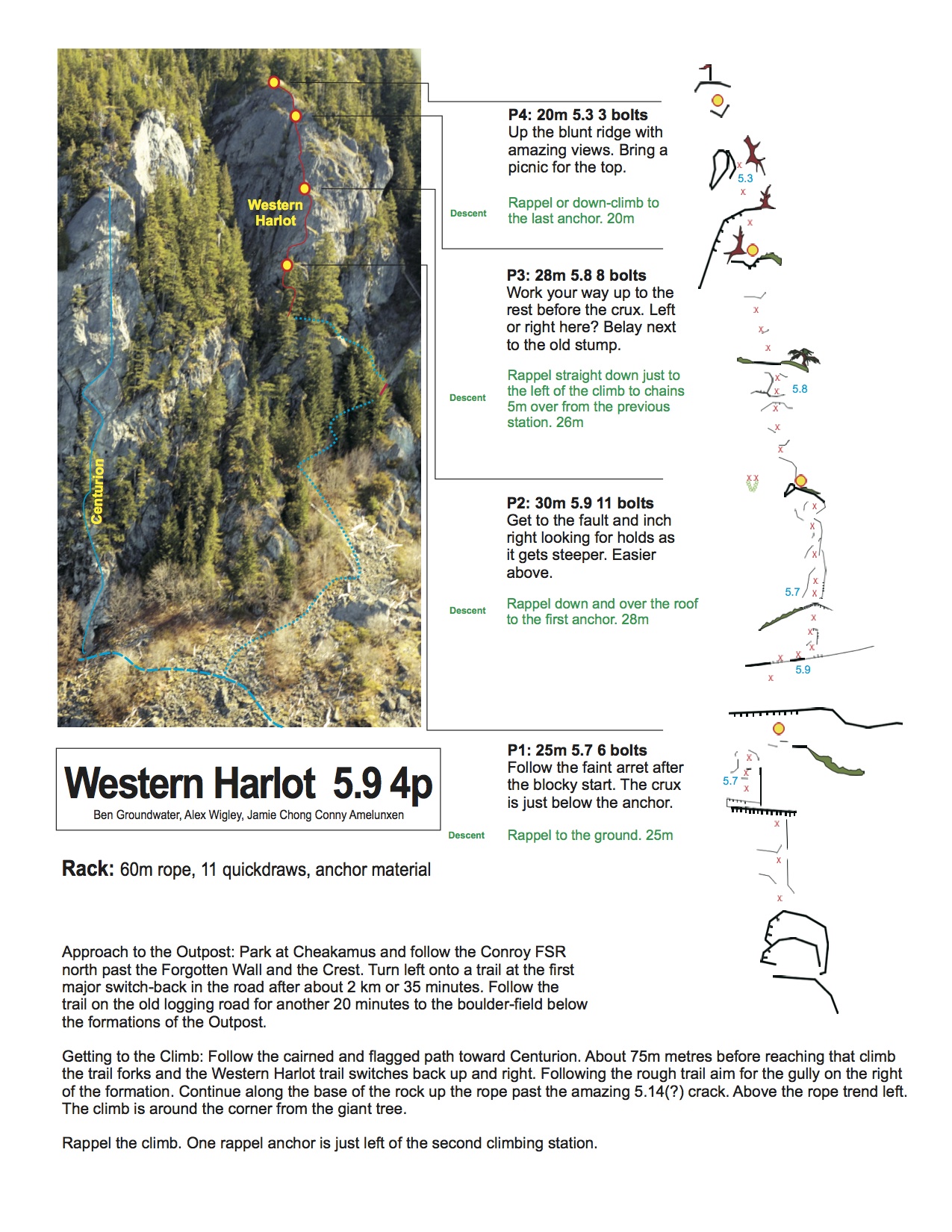
(Photo Above:  Ben Groundwater on the Spearhead.  Seeing is a luxury we don't always have.)
Using topographic maps, seems pretty basic, but recently I've read a bunch of stories on the internet where people have epics just because they didn't bring a map and compass.  Topo maps will give you an overview of the terrain from slope angle, avalanche path exposure, glacier crossing, and where large terrain traps my lie.  They also can illustrate the best ski line, white-out management handrails, broken portions of glacier (crevasses), and benches to utilize on the up track, all with just a bit of practice.  Not to mention topos can be used with a compass and altimeter to do a resection to find your location in case you don't have a GPS.

Topo maps are pretty easy to get a hold of as well.  They come as PDF's from the government, you just save them, then print them AND laminate them at any print shop.  Many stores have popular areas, where you can buy waterproof versions, and custom maps such as John Baldwin's series.

GEOBC
Free, printable PDF, 1:20,000 maps of all of BC.  Did I mention they are free?  Tends to be the fastest way to get a map, plus you have to option of customizing on the computer, or printing it to lay down some notes and route before laminating it.

IMapBC
An online and custom mapping software, which allows you to build your own map with a variety of different scales, colours, even orthophoto layers if available for the area your working on.

CalTopo.com
This website rocks.  It is another free topographic map provider, but it allows you to download custom sections of map, and also overlay it in Google Earth over the terrain so you can even see what the topographic terrain looks like in 3D.  But that's not all, it has maps for all of Canada and The USA.  Just click on the USGS 7.5' Topos section in the top right for 1:20,000 that include Canadian versions, that you would find on GEOBC.  And, if that's not enough, you can load these maps directly from the website onto your Garmin GPS.  The US section is ahead of the Canadian section, as it also has option for angle shading, and a bunch of really cool features.  Oh, and there's more, but one of the really cool KML/KMZ downloads is an giant 1:20,000 topo map overlay of all of Canada!

Hillmap.com
Hill Map is much like CalTopo, but has some different features such as overlays, GPS route planning,  and one feature I love... Points.  Click any point on the map, it will give you Lat / Long, AND a slope angle.  Perfect for planning white-out section where you may be concerned about avalanche hazard, thus knowing your okay, rather than just hoping.

Google Earth
Okay, if you are a skier or climber, and you don't have Google Earth it's time to get off your horse and carriage and drive a car finally.  This program and plugin is usually required for many of these websites, but is really useful when planning any trip.

Magnetic Declination Calculation 
This site will not give you any maps, but should never be skipped, as it simply gives you the magnetic declination required for your area to navigate properly.  Write it down on your map, so you aren't forced to calculate it in the field when stress levels can be high.

GeoBackcountry.com
Doug Sproul's amazing backcountry guide to Rogers Pass, utilizing Google Earth, Topo Maps, and route description all in one amazing package for your phone.  This is the future of guidebooks.

Route photo's come in next and are incredibly useful, especially when arriving on top of a mountain where you can't exactly see all the hazards and route from the top.  Do you go left or right?  Is there a traverse?  Cliffs?  Crevasses?  Most importantly, good skiing?  By looking at the route photo's, everything becomes easier as you can landmark on your way down to hit the line you have planned.  It also will help your mind to interpret the map data into a clear mental picture and get you dialled with your map reading.  Do a google search, and also try Bivouac.com, and John Scurlock's amazing aerial photo database.
(Photo Above:  The high end of shattered terrain, but important to see why a photo would be absolutely essential to make your way down this piece of terrain.  Most importantly, it also gives skiers an option of what looks the least hazardous for the conditions at hand.  Tisiphone Area, Lilloet Icefield.)
Another important photo tool, would be summer photos of glaciers, in order to get an idea of how shattered and broken the glacier can be.  It will also give you hints as to where you might find thin bridges, and shallow snowpack over it's coverage.  The photo above is taken in a moderate snowpack year, and can be useful in deeper snowpack years, to see what has changed and where some average years dangers might lurk.  Just note, the area above requires only the high end of experience levels to ski it and proper conditions to match, and rarely gets skied due to the gapping building size holes.  Just take note, glaciers change, so try to find out when the photo and plan accordingly.
(Photo Above:  1:50,000 identifier map, to help with an overview in the field.  Navigation is done best using the 1:20,000 map, with even more detail added to route and descriptions.  Use different colours when writing on the map, to identify certain features faster.  And if you want to get fancy, laminate the map after, so you can write on it every day with marker and erase the marker at the end of the day.)
Now coming back to your topo map that you've printed and referenced so many times, it's time to draw on it.  Take your notes, concerns, and plans and make sure they are on the map so there is as little to think about in the field in order to concentrate on what's in front of you.  This will be useful when navigating in a white-out as well.
(Photo Above:  A long while ago, navigating the Dais & Franklin Glaciers, in weeks of white.)
If the clouds and storm do come in, a white-out plan pre-preparred is your saving grace, and the difference between an experienced backcountry skier and a newbie.  All of your trip planning, the topo maps, photo's, all combine to give you the basic frame work required to put together the white-out plan.  By now, you've identified benches, terrain features, hazardous areas, and safe spots.  All you need to do is choose your route that travels through those and around specific features.

When writing the whiteout plan, you'll need waypoints to input into your field book and GPS, route description to read in the field, compass bearing and back bearing, as well as elevation.  Using UTM is much better than Lat/Long as it's much faster and easier to find your location on a paper map.  These combined provide you with a step by step walk through of the mountains, and allow you to move your way through the white room without being stopped in your tracks completely, or potentially walking yourself into an accident.
(Photo Above:  Basic white-out plan, which can be even more detailed if you are expecting poor weather.  The more detailed the less guess work. - Note UTM above is short hand, and not missing northing.)
The white-out plan not only will help you make your way through terrain without seeing it, but will also be helpful in telling how long it will take.  For trip planning purposes, plan on different conditions and different types of terrain taking different times.  Below I've listed baseline travel times, which can differ for individuals, gear, and amount of packed weight so adjust accordingly.

5km/h on good trails
3 km/h on open terrain
1 km/h rough travel
less than 1 km/h in a true whiteout

Preparation for a day trip, or multi-day trip, truly makes for amazing days in the backcountry with really cool loops.  By doing this, you are not only prepared for any navigation challenge, but better prepared to deal with every other hazard from glaciation to avalanches as you are forced to consider everything before leaving.  Go to new places, practice, and always leave yourself options to work with.  Better days skiing, are just more amazing days to think about when your stuck working or on a forced weather day.

07 January, 2014

TLH Setup 2014

The Guide's work is never done, and it's an interesting year out there, as British Columbia has definitely seen so far.  We just did a shift working on setting up TLH Heliskiing, focusing on getting everything ready, but more importantly sussing out the snowpack and checking out glaciers.

I think the one thing many people can take home from a few of our observations is that we need more snow, but not as much for our snowpack depth, but for the coverage on glaciers.  Crevasses have started to bridge, however, with the winds they are bridged very thinly and very discretely.  This was discovered very quickly, when we descended down a pocket glacier (probing our way down), and found a few crevasses that were perfectly smooth on top with no visible sagging.  So with that discovery, our goal was to find runs that either had smooth glaciation with no holes, or simply no glaciation at all (at least until we get a number more big storms coming through).
(Photo Above:  Scott Flavelle probing a unknown width but deep crevasse, perfectly concealed by the wind and snow, only a small amount of snow bridging it.  Notice the clues on the rib in the background, where the crevasse goes up to, and subtly suggests it's there.  Too bad those clues aren't everywhere.)
(Photo Above:  Deciding we don't want to ski down a glacier riddled with slots that we are unable to see.  Erika Flavelle and Conny Amelunxen escaping to a new pick-up.  You can go Ski Mountaineering when hell-skiing!)
The other main goal while setting up is to establish a strong understanding of what is going on in the snowpack.  We go out, dig multiple profiles, in different elevation bands, different terrain features, and different aspects to learn what's going on.  During the guides meeting, we focus on what we don't know, and then form our field objectives around learning and shedding light on those concerns.  By the end of the week, we've got the snowpack pretty sussed out, and understand the variety of changes though out the tenure which is a touch larger than Switzerland.  This process is key for us, but the process is standard even for recreationalists.  Find our as much information as possible, if you have questions about an aspect, elevation, or layer, answer those questions.  Just don't go ski something if you are unsure.

Overall, it's great to get out check out the terrain, travel through the mountains, and of course heli ski with friends in between "working."
(Photo Above:  Alex Wigley on White Cross, "working".  Photo Credit:  Conny Amelunxen)

15 December, 2013

The Problem With Avalanche Rescue

Nearly everyone who takes an CAC AST 1 or 2; ITP 1,2,3; AAA Level 1-2-3; or any other form of avalanche course knows that if you have to rescue someone you need to act fast.  Most people won’t last past 12-15 minutes under the surface, one third may suffer from trauma, and others may be buried deep.  There is always practicing rescue from right beside the slide path, but while practicing right beside the slide path is for practice it’s not realistic.  Typically travel times must be factored in, hazard, and transitioning from downhill to uphill in some cases.  Then there are a maraud of other factors to think about, so let’s start going through the problems in order to put together a bigger picture of a rescue.

(Video Above:  Unbelievably lucky guy in an big avalanche, with a helicopter on scene, and rescue team on standby.  Not the reality that backcountry skiers have the luxury of.)
First, before anything, everyone in the group needs to have a 3 or 4 antenna avalanche beacon, anything less is out dated technology and should be replaced (why not just have the best and newest beacon, your life is worth it right?).  Avalanche beacons are great, but do have issues like any piece of electronics, and many people choose to either disregard those bugs or just don’t know about them.  So what can interfere with you Beacon signal?  Any piece of electronics within 50cm of the Beacon such as Cell Phones, camera’s (especially those with GPS), GoPro camera’s mounted on the chest (GoPro on the head is fine), GoPro wireless & bluetooth controllers, iPods, heated gloves, magnets on the front of jackets, and even within a recent study that says candy bar wrappers that have foil in their wrappers that sit in the same vicinity as the beacon could create issues!  These also aren’t just problems for searchers, but those who are buried, so be weary and keep your gizmos, well away from your beacon, inside your pack.  Always wear your beacon under your jacket (never keep it in your pack).

Now those skiers and snowboarders who have high DIN, or non-releasable bindings, have a number of things to be concerned about.  While caught in an avalanche, skis/snowboards, and poles strapped to the hand act as anchors and pull the person under the surface of the snow in the avalanche.  They can also cause trauma, twisting and pulling body parts in different directions.  So the number one goal is staying on the surface, followed by avoiding obstacles if possible, and covering your mouth with your arm all while attempting to swim off the side of the slide.  One thing that can help is an avalanche airbag, which is the only product on the market that attempts to prevent burial.  So if you can’t get out of your skis or board, you may be buried deeper and/or with trauma issues for your rescuers to deal with if they get to you in time.
(Photo Above:  Justin Ormiston shredding the committing N Face of Mt Fitzsimmons in thigh deep snow.  Better be sure it's stable, there's no fooling around with this big face.  Terrain traps, steep open large terrain, and big spacing between partners.)
Distance is the next key issue.  How far away is everyone from the avalanche and it’s deposition zone?  Are they above and can quickly ski down in order to start searching, or do they have to put their skins on and start running uphill to the site?  Being far away, halfway down a mountain, and/or in a less than ideal proximity adds a huge amount of time to the rescue effort.  Did that person get swept into a terrain trap?  Speed is essential at this point, this is made from fitness, ability, distance, searching capabilities, skill and strategic shovelling.
(Photo Above:  Natural avalanche, due to the trees, this area would almost certainly result in trauma if caught in a slide.)
Now your friend has a beacon on, doesn’t have a cell phone around his/her beacon, got rid of their skis, and was lucky enough to be buried close enough to you and the surface for you to get to them in time.  Now what?  Many avalanche victims suffer from trauma and can die from that alone.  Some may be unconscious, not breathing and/or have a blocked airway, unable to walk, spinal injury, hypothermic, etc.  Combine all your skills from avalanche rescue, wilderness first aid, survival, rescue planning, as well as helicopter knowledge, and you have half of the equation done to getting someone out alive.  You also need the right gear to drag or move that person to safety, deal with their injuries, and get them to medical care immediately.  How will you move them in waist deep snow, will moving them make the injury worse, and do you have enough light left in the day to get home?  
(Photo Above:  Practicing moving patients in a toboggan through undulating terrain, complete with cliffs, and deep snow.)
Now let’s say the incident has happened early enough in the day, the weather and wind is good enough for a helicopter to fly, and you need to get that helicopter in.  Most helicopters need a spot to land where the pilot has depth perception (small tree, rock, anything that when they come in and the snow gets blown up in the air they can maintain sight).  They also need a flat area that is large enough to land, otherwise they will be forced to sling a patient out and wind/visibility really becomes a factor.  Bell 212’s have a 48ft blade span and require clear 100x100ft area to land, and prefer to land into the wind.  Bell 407’s are a bit smaller, with room for less casualties, and have a 35ft blade span allowing them to land in only a slightly smaller area than the bigger 212.  There are many other helicopters out there, but these are just two of the classics, although we do see a few more B3’s out there from time to time.  So if you do have a spot, you will need to let them know if they will need it in stretch configuration, or seated.  As well as if they need to bring a paramedic with Advanced Life Support training, and the type of gear they may need to assist you.  A complete description of your problem is vital.
(Photo Above:  Testing the spinal board patient transport setup in the Bell 407)
Time between avalanche and getting to the hospital is also critical.  Seriously injured patients may only have the ‘golden hour’ to get advanced medical help, whereas others may last much much longer depending on the severity of the injury.  Hospital distances and resources must now also come into question, which hospital is best suited to deal with the issue at hand, and how far away is that.  For example, it’s my understanding that the Whistler Health Clinic can only accept Twin Engine helicopters such as the 212 at this time, but not the 407 which is required to land at the heliport and rendezvous with an ambulance adding to rescue times.  So it’s important to have an idea of what kind of health care is closest to you, and how easy it is to get there.

There is a lot to think about when it comes to a full fledged rescue.  SAR Teams are amazing at what they do, and will always be there working as hard as possible to get you and your friends out.  However, make no mistake, if a handful of these problematic factors are present, they compound on each other and make rescue much more difficult.  The key is to identify potential problems first, and consider them with your trip planning and also with how you ski in the backcountry.  Habits such as not skiing with a cell phone that is on and keeping it your backpack is great, regrouping at safe and smart locations is vital, and being prepared for anything is key.  By thinking of the consequences of a rescue in the terrain we're in before hand, we can make better decisions, and set ourselves up for success if we are faced with the worst.  We are very vulnerable, just how vulnerable is up to us.

24 October, 2013

10 Tips To Have The Best Ski Season Yet

Last year I had published a handful of tips at the bottom of a post to have the best season yet.  A lot of people really liked the idea, asking questions in emails, and I felt to expand upon those ideas as a set of rules for a great season.

But what is a great season?  A great season is a season that allows you to greatly expand your experience as a backcountry and mountain person, build your skills, and give you adventures of a lifetime that are constantly different and always providing new ways of exploring the vast possibilities of what the mountains have to offer.  Learning is what makes the best memories and makes us stronger human beings in the process.  So with that, enjoy!

10 Tips To Have The Best Season Yet.
10.  Take one course that will expand your skills.
There are tons of great courses out there, avalanche, mountain rescue, first aid, navigation and more.  Take a course in the area you feel weakest in, and round out your experience.  Handling anything in the mountains is vital to survival.  The Canadian Avalanche Association and American Avalanche Association have a plethora of different courses, ranging from professional Industry Training Programs (Level I, II, III), Mountain Weather, Avalanche Control Blasting, AST Level I or II, Avalanche Rescue, etc.  Or if you into something else, take a glacier travel course with an ACMG guide, and learn crevasse rescue and risk mitigation techniques.  All courses expand your learning, are ridiculously fun, and will help bring you to more places you dream of going.
(Photo Above:  The beautiful and broken backside of Mt Athelstan, perfect for swallowing school buses and entire logging trucks)

9.  Train
Training and being prepared goes a long way.  It makes the difference from skiing objectives that are nearby suffering from tracks, and remote untouched landscapes that excite and scare you.  It is the difference between setting the skin track and being the first out to a peak, and being one of dozens heading out on a well trodden skin track.  Leave everyone behind.
8.  Ditch the heavy gear.
That heavy pair of Duke or Guardian bindings are making sure that all that hard training doesn't amount to much.  They're slowing you down and you know it.  Buy a pair of tech bindings, ditch the alpine boots, and maintain the same performance on the way down.  The choice is yours, ski hardcore places or look hardcore.  It's worth it, just check your ego at the door.
7.  Learn "Old School" Skills
These days everyone relies on GPS and gadgetry to travel around in the mountains.  And why not?  It's there so we should use it.  However, if those should fail we should always be able to make our way around and home without the use of technology.  Learning resection, finding North without a compass, and telling sunset times from the sun are useful skills that can be added on to technology uses to move more efficiently in the mountains.  Besides, if you have a GPS and totally screw up your navigation while practicing without it, it's there for you when you need it.
6.  Ski an area completely differently than you are used to.
Everyone has their favourite stomping grounds.  An area or traverse where you can go, know the terrain, and have fun regardless of how many times you've been there.  But before you go the standard route, think about doing it differently.  For example, if it's a traverse, go do it backwards, if it's a couloir, try climbing a different route to access it, rather than boot packing straight up it, a circuit add another peak or variation.  The options are limitless, but as soon as you break the mould, you'll discover new features, and have a better view of the terrain you regularly travel though.
(Photo Above:  Friend's on the Anniversary Glacier completing the Joffre Slalok Loop in reverse)

5.  Ski at least one full moon night this year.
Every backcountry skier has heard of amazing nights where the moonlight makes the night landscape appear as if it's daytime.  Nothing is more special than dropping into an untracked couloir under a full moon and skiing powder under the stars without a headlamp.
4.  Head on a hut trip every month, don't skimp on really good food.  
Hut's are great.  They are a great staging point to get amazing skiing in remote areas, pack lighter (or heavier on food), and have the added comforts that a tent or snow cave could never offer.  That being said, some huts are busy, full of people who have little intention of skiing, are loud, snore, and can be overcrowded.  So to revise, head to a remote hut with your friends, socialize on your own terms, and sleep comfortably throughout the night.  You'll be rewarded with no people, a remote wilderness to yourself, and your own personal slice of paradise.
3.  Find the longest fall-line ski runs in all your favourite areas.
There are runs in every area that people ski, but surprisingly, some of the best lines are not always the ones getting skied regularly.  As a matter of fact, I can go ski my favourite lines off the back of Whistler or Blackcomb (also the longest lines) without ever seeing any tracks.... even when there are lots of other tracks on other runs.  Bottom line:  find the best lines, ski them as much as you can, keep them for yourself.
(Photo Above:  Christina Lusti cruising up Mt Curry, after a season of skiing the Coast's longest lines)

2.  Ski a new area every week.
#2 and #1 are really a tie, as skiing a new area every week is just as memorable as a big trip.  Each time you head into new terrain you build skills, expand your navigational experience, and generally don't get bored with constantly going to the same hut, same area, and becoming more complacent in dangerous terrain.
1.  Plan and execute that big ski trip you've thought about for years.
This is a no brainer.  Go somewhere bigger than you've ever been or dreamed of.  These trips are burned into your memories from the commitment, effort, and thought behind them.  Friends become brothers and sisters, decisions are forced to maintain movement, and communication becomes soundless between partners as seriousness increases.  You know you want to live your dreams, now do it.

28 September, 2013

New Route: "Western Harlot" 4p 5.9

Squamish, and generally the entire Sea To Sky, has a serious load of climbs to get on.  Some of the hardest climbs in the world, and also the most classic, in both sport and traditional styles.  There are lots of great routes, but we still need more, especially in the lower grades for those who are just getting into mountain sports.  Routes that aren't super hard, such as the beautiful Squamish classic "Daily Planet" which goes at 5.12a on gear, but more like the ultra classic "Star Chek" (minus the runout) which is 3-4 pitches with it's crux being 5.9.
(Photo Above:  Heidi Savage following pitch 2 of the classic 'Star Chek')

Conny Amelunxen, Jamie Chong, Ben Groundwater, and I spent a number of days hauling ropes, drills, batteries, brushes, bolts, and other miscellaneous gear in to the route.  We set fixed lines to jug each pitch, and find the best moves on the route, all while cleaning moss, dirt, and loose rock from the route.  Each pitch was bolted, with bolted stations and chains, along with a rappel route beside the climb that also uses two of the routes stations.
(Photo Above:  Alex Wigley leading the crux pitch, photo: Conny Amelunxen)

Stoked to have finished digging off ledges, pulling moss, and generally getting beat up tired from working 8+ hour days, we decided to make a quick first ascent.  The route was definitely worth the time and effort.  Each lead is incredibly well protected (as planned), for the leader climbing at his or her limit, but really cool thoughtful moves in a beautiful position above the trees made the climb an classic in our eyes.  The climb faces the Tantalus range and the final view from the 'picnic' area at the top is amazing.  After climbing the route for the first time, I have to say cleaning routes is definitely fun and hard work, but it's also great fitness and super rewarding.
(Photo Above:  Jamie Chong enjoying the Tantalus View from the 'picnic' spot on the top of the route.  Photo: Conny Amelunxen.)

What might this have to do with skiing some may wonder, but climbing has everything to do with skiing, and is just as fun.  The only way to elevate your ski mountaineering skills and get on some real terrain, is by learning to climb.  Climbing is important to start feeling comfortable in high exposure, technical terrain, especially in areas where protection is sparse. Being able to push your limits up high in the mountains can only come from pushing your limits down low in the valley.  Skills need learning, technique needs polishing, as the only way to get better is to try harder and focus.  Where better to start than well protected sport routes?
(Photo Above:  Route Topo, click on image for a larger view)

Hope people new and well seasoned like the route!
Sendage.com - Route Info 

01 June, 2013

A Lesson In Pain - Burning Out

The mountains are brutally hard, beautifully brutal.  They are merely as hard as we make them, as each one has an easier route, or we have the luxury of choosing one that is closer.  The mountains reveal their true beauty as we step beyond the easy routes and ones that are closer to home.  By traveling faster, farther, in harder, bigger terrain, they reveal more to us.  And we experience them in a much deeper way.
(Photo Above:  James McSkimming, skiing the beautiful shoulder of Mt Matier's North Face)
Recently, in an epiphany, I had realized how much harder they can be.  I raced through mountains in Italy in a Teams Race in the 2011 World Championships, and gave everything I could give to moving through those mountains as fast as possible.  I gave more than what I could give, and borrowed all the energy I could to accomplish what I felt was most important at the time, I told myself nothing is more important that catching the racers at the front.  I drained everything, tasted blood for days after the race, sacrificed my body to that race, literally, and felt psychologically destroyed.  I learned in an epiphany that I had burnt out, a mere 1.5 years later, as I couldn't bring myself to the depth of suffering that I once enjoyed so much.  But now after that 1.5 years, ready to give my body back to the mountains, and not to a race course, I realized the importance and lessons of draining everything.

Racing on the Ski Mountaineering Team was amazing, and I may think about doing it again.  I trained hard, focusing all day on training, recovery, nutrition, hydration, each aspect every minute of every day.  I focused on it, telling myself it would pay off to get back into the mountains, and complete the goals I had in mind.  It did.  But what I didn't think of is the fact that it may take away from that as well, especially if I went to intensely.  My ego told me I could race and perform to maximum power in the mountains, I felt really strong, but with the mountains you are sometimes just waiting to get a real full dose of the truth.  I simply couldn't recover from it, hitting rock bottom, for an athlete.
(Photo Above:  Slovenian Competitor living inside the 'Pain Cave'.  2011 Vertical Race, WC Italy)
Recovering, after the burn out, was hard.  I still trained, did some racing, got out in the mountains, but couldn't go to the depths as I once could.  I wanted to, but both mind and body, held back.  And now finally recovered, like a light switch got flipped, I'm ready.  But have lost 1.5 years of growth to the recovery.  Now getting out training, looking towards routes I've dreamt of for years, and feeling mentally and physically ready to take on again I have started looking forward to that uncomfortable comfort of the pain cave.

What may hurt people to think, which I find has helped, is to tell yourself the truth (it hurts).  You are not special, you are not insanely strong or fast, you have merely put in a bit of time to make yourself slightly better, but realize this; overall, you are slow, you can always train and recover better, you can always do more, you are not dedicated enough, you are frail, and one day you will die.
(Photo Above:  Justin after a long day of being on the move, Whistler, BC.)
Now, ski-mountaineering with a friend, watching them be introduced to that at first seemingly horrible dark pain cave I can truly begin to start understanding the mentality behind the growing in the mountains.  It's not the acceptance of pain and fear, but welcoming it in, and keeping it close for long periods at a time.  The more time spent, in pain and fear, the deeper the experience.

Living inside the pain cave becomes a warm comfortable recess of the mountains in time.  Inside it our human frailty and softness are equally apparent and also easily left behind, the choice is ours in which way we choose to lead it.  We can accept the fact that our pain overwhelms our senses, but understand it is merely a reaction to growth, as we grow stronger with each step and movement forward.  Only when we've been inside the cave long enough, stripped away our ego, our thoughts of what or who we are, and spent the energy that is required to think of these distractions, that we can discover our true self and realize what needs to be done in order to continue on our path in the mountains.

"The greatest enemy will hide in the last place you would ever look."  -  Julius Caesar, 75 BC.
(Photo Above:  New lines to test out, requiring the mind to lead not the body.)

SkiMo Racing And Ski Mountaineering Training Tips
1.  Identify Weaknesses
What is your weakness?  Do you get scared on mixed rock and ice terrain?  Are you slow on boot packs?  Do you bonk after long periods skinning?  Whatever it is, identify your weakness, and seek out that weakness.  If you are afraid on mixed terrain, go find objectives with more mixed terrain, study gear and climbing techniques more.  Bonk on long skintracks?  Learn about nutrition, timing, and record your results in a training journal (what helped, what didn't, how you felt at the end of the day hours later.)
2.  Change the way you are training
The only way to continue to grow is to not stagnate.  Never do the same thing over and over again, change your long distance routes, interval inclines and technical courses, bootpack with different amounts of weight on your back, drag a tire, just do everything in your power to ensure your body does not get used to your training.
3.  Learn from your mistakes.

Recovery
1.  Sleep
8 Hours a day minimum.  Add 1 to 2 hours of sleep for added stress at work, life, or harder than usual effort.
2.  Nutrition
High quality proteins lean organic meat, chicken breast, eggs, cooked without fats or heavy sauces.  Good fats such as avocado's, fish oil, extra virgin olive oil (not heated), and lots of vegetables.
3.  Yoga
Yeah, so I'm saying yoga.  For a long time I've liked a bit of yoga, but have been reluctant to engage in it as many people refer to it as a true form of fitness, and the best way to be extremely strong.  I disagree, but as this is not a rant post about yoga, here's why I like it now.  Finding the right stretching classes have helped align my body better, keeping my body a bit better balanced, improving my recovery, and loosening up tight muscles that aren't so easy to stretch.  Supporting muscles used in climbing, and skiing, sit in better positions afterwards and I become far less likely to get an overuse injury.
4.  Mixing It Up
Possible the most important thing out there.  Skiing has been one of my most important focuses in life, but taking a step back, taking a break, and enjoying other activities have only helped it and my enjoyment of it.  Go biking, climb, just do something that is fun, requires your athletic skill and energy, without your only goal being skiing. 

22 April, 2013

Closin' It Down On The Last Week At TLH

I just got back from the last week of operations at TLH.  Great group, actually fantastic, and probably some of the best conditions we've had all year.  Dry deep snow, sunshine, and a single helicopter to use in an area bigger than Switzerland.
(Photo Above:  Alex Wigley (left) Ken Gray (right) flying laps in The Gun.  Credit:  Andrew Doran)
Guiding this week wasn't as simple as most spring weeks, as there was a hair trigger layer of 20mm Surface Hoar buried 30-75cm down on a hard Melt Freeze Crust.  The snow on top of it was high quality dry snow, but continued to build a slab with multiple convective flurries dropping 10-25cm each day on top of it.  Needless to say, anything above 2350m steeper than 30 degrees was avalanching when we walked or landed on ridges.  It took careful planning to negotiate through and avoid run outs.
(Photo Above:  One of many remote triggered avalanches on Surface Hoar)
(Photo Above:  Alex Wigley leading another line in The Gun.  Credit:  Andrew Doran)
As for our guests, one in particular spent the time to create an amazing video of his trip, and it turned out great.  Check it out.


Heli Boarding BC, Canada, April 2013 from Niki Luysterburg on Vimeo.
Great season, stoked to be out exploring such amazing terrain with such great people.